Friday, September 4, 2009

Quarry Rock, Deep Cove, North Vancouver


Things to Do: Walk, Hike

Dog Friendly: Yes

Distance from Vancouver: 21 KM; 30 Minutes

The trailhead begins along Panorama Drive past the park.


Driving Directions:


Just off the shores of scenic Deep Cove in North Vancouver sits a large rocky outcrop known as Quarry Rock (also known as Grey Rock in some hiking books). A hiking trail which is also part of the easternmost section of the Baden Powell Trail, leads to this point offering scenic views of Indian Arm and the mountains around Belcarra.

The start of the Baden Powell Trail begins along Panorama Drive just beyond the park area. Look for the sign on the left side of the street and walk up the edge of the driveway towards the wooden steps. The first section of the trail climbs quickly up the set of stairs and then up and over the maze of tree roots.

The terrain is typical of North Shore hikes; densely wooded areas of Douglas Fir and Hemlock trees, small creeks from mountain runoff, and the smell of fresh forest air. Continue over the small wooden bridge as the trail begins to level.

After 30 minutes, the trail heads down towards a large wooden bridge. Cross the bridge and ascend up a set of wooden stairs on the other side. Another 10 minutes and you reach a fork in the trail where the left side goes up a steep embankment. Go right towards the clearing in the trees as the trail climbs up onto the solid rock. You have arrived at the Quarry Rock. Climb up to the highest point to check out the view before staking out a spot to sit and relax.

On a warm, clear day, one could sit for hours enjoying the tiny boats below and scenic surroundings off in the distance. When it comes time to return, head back towards the clearing and back along the trail as it weaves through the forest and back towards Deep Cove.


How to get to Quarry Rock

Estimated Driving Time from Vancouver: 30 minutes

Head eastbound towards Highway #1 (Trans Canada Highway) and enter the highway heading northbound. Cross the Iron Workers Memorial Bridge, also known as the Second Narrows. Take the third exit (Exit #22) after the bridge towards Mount Seymour Parkway. After exiting the highway, stay in the right lane and immediately turn right at the lights onto Mount Seymour Parkway. Follow Mount Seymour Parkway for 5km until a traffic light at the bottom of a steep hill. Turn left onto Deep Cove Road and drive for a few minutes towards the community of Deep Cove. At the 4-way stop, turn left onto Panorama Drive and park in the parking lot or along the street. The trailhead begins along Panorama Drive past the park.

View a map of Driving directions to Quarry Rock.


Additional Information


dog icon Dogs at Quarry Rock

Dogs are allowed to be off-leash but under control at all times.

Sunday, July 26, 2009

GROUSE MOUNTAIN, NORTH VANCOUVER, BC

The Grouse Grind® Trail

The popular Grouse Grind® is a 2.9-kilometre trail up the face of Grouse Mountain, commonly referred to by Vancouverites as “Mother Nature’s Stairmaster.” Over 110-thousand hikers a year take on the challenge of the rugged terrain and steep climb, starting at the Valley Station and finishing at the Peak’s plateau, for a total elevation gain of 2,800-feet. The average climb takes just over an hour, with beginners requiring up to two hours to complete the trek.

Grouse Grind A Mystical Place by Arlene Gee.

grouse grind: grizzly bear by sheep sheep.


THE REFUGE FOR ENDANGERED WILDLIFE:

Grouse Mountain Bears by The Kids and Kahlie.


Imagine a wilderness sanctuary where endangered animals can play, protected and secure. You will find all this and more at The Refuge for Endangered Wildlife, a research, education, and conservation centre at the top of Grouse Mountain. Dedicated to becoming a world leader in preserving both flora and fauna at risk. The Refuge offers leading-edge interpretative programs that make learning about nature fun and fascinating.

The Refuge for Endangered Wildlife is principally comprised of a five-acre mountaintop habitat that is home to two orphaned Grizzly Bears, and a Grey Wolf habitat located at the base of the mountain. The Wildlife Refuge is included with your Grouse Mountain Admission. Be sure to come up early in the day so you can fit them all in.


ECO-WALKS

Map of the mountain by kimba.

Grouse Mountain Peak by lasalli.


REIFEL BIRD SANCTUARY, DELTA, BC

ADDRESS: 5191 ROBERTSON ROAD, DELTA, BC

DISTANCE FROM VANCOUVER: 35KM, 50 MINUTES

DRIVING DIRECTIONS:


HOURS: 9AM - 4PM DAILY

George C. Reifel Migratory Bird Sanctuary is a protected area in Delta, British Columbia, Canada and is part the the Fraser River estuary. The area includes managed wetlands, marshes and dikes. The 300-hectare (740-acre) area has numerous walking trails, bird blinds, lookouts and a gift shop. It has resident nesting sites for Sandhill Cranes, Bald Eagles, Mallards, Spotted Towhees and many others. Migrants include, Lesser Snow Geese, Greater and Lesser Yellowlegs, Long-billed Dowitchers, and Western Sandpipers. Over 268 species have so far been recorded in the Sanctuary. The sanctuary is open year round from 9 am to 4 pm local time.

Our Reifel Bird Sanctuary VII by iano50.

Weird Weather Day-Reifel by iano50.

Reifel Bird Sanctuary 1 by blue_topaz.

A Duckling Candid by J Bespoy.


RICHMOND NATURE PARK, RICHMOND, BC

ADDRESS: 11851 WESTMINSTER HWY, RICHMOND, BC

DISTANCE FROM VANCOUVER: 16km, 30 MINUTES

DRIVING DIRECTIONS:


Richmond Nature Park 5 by iano50.


Facility Hours

Nature Park: open daily from 7am until sunset. Admission is free.
Nature House: 9am - 5pm everyday, except December 25th & 26th, January 1 and November 11. Admission is by donation.

The Richmond Nature Park consists of 200 acres of the raised peat bog habitat that once covered large portions of Lulu Island. Four walking trails totalling 7 km in length provide visitors the opportunity to encounter plants and animals in bog, forest and pond habitats. The shortest trail, an elevated boardwalk around the Park pond, is wheelchair accessible. Other trails are soft-surfaced with wood chips. All trails are well marked, and a free trail guide is available in the Nature House.

The park is always changing. In spring, visitors can see and hear the territorial fights of the hummingbirds as bog flowers bloom below. Summer days are long, and the trails ideal for cool evening walks. Autumn brings owls, northern migratory birds, and spectacularly coloured foliage. In winter, visitors can hear varied thrushed and see winter birds at the feeders, or follow animal tracks in the snow.

The park is very fragile environment, so dogs and other pets are not permitted, and visitors are requested to remain on the marked trails. No plants, plant parts, or animals may be removed from the park. Please do not attempt to feed the animals, for your own safety and the health and safety of the animals.

Nature House
An interpretive centre located at the entrance of the Nature Park. It features interactive displays and games about the park, the bog, and other aspects of nature. There are activity kits, and active beehive, a small collection of live animals, and a gift shop.

Picnic Area
A covered shelter containing 6 tables is adjacent to the Nature House. There is a children's play area and wheelchair-accessible washroom near the Nature House. There are no food services in the park

CHINATOWN, VANCOUVER, BC

Vancouver's Chinatown by tiny bites.


Chinatown in Vancouver, British Columbia, Canada, is the Western Hemisphere's second largest Chinatown in area (after San Francisco), and third largest in population (after San Francisco and New York City). Centred on Pender Street, it is surrounded by Gastown and the Downtown Financial and Central Business Districts to the west, remnants of old Japantown and the Downtown Eastside to the north, and the residential neighbourhood of Strathcona to the east. The approximate street borders of Chinatown's commercial area are the alley between Pender Street and Hastings, Georgia, Gore, and Taylor Streets, although its unofficial boundaries extend well into the residential area east of the Downtown Eastside. Main, Pender, and Keefer Streets are the principal areas of commercial activity.

Due to the large ethnic Chinese presence in Vancouver—especially represented by multi-generation Chinese Canadians and first-generation immigrants from Hong Kong, the city has been referred to as "Hongcouver" (a term considered derogatory by some)[2]. Chinatown remains a popular tourist attraction, and is one of the largest historic Chinatowns in North America. However, it went into decline as newer members of Vancouver's Cantonese Chinese community dispersed to other areas of the metropolis. It has been more recently overshadowed by the newer Chinese immigrant business district along No. 3 Road in the Vancouver suburb of Richmond, which had been an Anglo-Saxon bastion until the 1980s. Many affluent Hong Kong and Taiwanese immigrants have moved there since the late 1980s, coinciding with the increase of Chinese-ethnic retail and restaurants in that area. This new area is designated the "Golden Village" by the City of Richmond, which met resistance to the proposed renaming of the area to "Chinatown" both from merchants in Vancouver's Chinatown and also from non-Chinese residents and merchants in Richmond itself.

Chinatown was once known for its neon signs but like the rest of the city lost many of the spectacular signs to changing times and a new sign bylaw passed in 1974. The last of these was the Ho Ho sign (which showed a rice bowl and chop sticks) which was removed in 1997. Ongoing efforts at revitalization include efforts by the business community to improve safety by hiring private security; looking at new marketing promotions and introducing residential units into the neighbourhood by restoring and renovating some of the heritage buildings. Current focus is on the restoration and adaptive reuse of the distinctive Association buildings.

Vancouver's Chinatown by Librarian In Black.

Capilano River Regional Park, North Vancouver, BC

ADDRESS: 4500 CAPILANO PARK ROAD, NORTH VANCOUVER

DISTANCE FROM VANCOUVER: 10KM, 15 MINUTES

DRIVING DIRECTIONS:


BICYCLES: YES

DOGS: ON LEASH

Capilano River Regional Park, North Vancouver - just minutes from downtown Vancouver

Hatchery MapDirections:
Capilano Road north (Capilano Road exit from Hwy #1 or North Vancouver exit off Lions Gate Bridge, then left up Capilano Road) .5 km past the Suspension Bridge. Turn left on to Capilano Park Road (look for sign “Capilano River Regional Park“) and proceed down 1 km to end of the road.

Hours of Operation:

  • Nov - Mar 8am - 4pm
  • Apr 8am - 4:45pm
  • May 8am - 7pm
  • Jun - Aug 8am - 8pm
  • Sept 8am - 7pm
  • Oct 8am - 4:45pm
The hatchery office hours are from 8am - 4pm, Monday to Friday. For more


LINKS: http://www.greatervancouverparks.com/ClevelandDam01.html

Saturday, July 25, 2009

LYNN CANYON PARK, NORTH VANCOUVER, BC

DISTANCE FROM VANCOUVER:


http://www.seethenorthshore.com/lynn/3576-21a.JPG

Lynn Canyon Park
is a municipal park in the District of North Vancouver, British Columbia. When the park officially opened in 1912 it was only 12 acres (49,000 m2) in size, but it now encompasses 617 acres (2.50 km2). The park has many hiking trails of varying length and difficulty. The Baden-Powell Trail passes through the park crossing over the Lynn Canyon Suspension Bridge.
The park is a second growth forest, with the most of the oldest trees being 80-100 years old. Evidence of logging in the area can be found in the many large stumps, complete with springboard notches. Cliff jumping is popular with Lynn Valley youth in the summer. The series of Stargate SG-1 and Atlantis both use the area for filming.

http://www.seethenorthshore.com/lynn/0154-28.JPG

CENTRAL VALLEY GREENWAY BIKE PATH, VANCOUVER, BC


Regional map showing Central Valley Greenway


bridge on the Central Valley Greenway by Duckdeux.


Riding the Central Valley Greenway

“The Central Valley Greenway is a 24-kilometre pedestrian and cyclist route in Metro Vancouver, running from Science World in Vancouver to New Westminster, though Burnaby. The Greenway officially opened on June 27, 2009 with opening celebrations, guided bike tours and walking tours on sections of the Greenway. Despite its official
opening, some sections are complete on an interim basis and are anticipated to be upgraded in the future.” - Wikipedia

A week after the official Grand Opening, I set aside an afternoon to ride the entire route out of Vancouver, through central Burnaby, and into New Westminster.

There is finally an accurate map available from TransLink. An online version is here but you really want the paper version so you can take it with you. There is also a route posted on bikely.com here.

Central Valley Greenway: Burnaby, Piper Spit detour by buzzerblog.

Most previous maps, either printed or on web sites, are inaccurate and may end up directing you down some dreadful freeway in Burnaby, so get this map before you start. Even with it, I got lost once, and thereafter learned to ask people if I was unsure of the way ahead.

The City of Burnaby is sometimes not so good when it comes to bike route signage. They mean well, but often miss the final details that make the difference to bewildered cyclists who have never been there before. I knew that already, so I went to the ride guided by the Vancouver Area Cycling Coalition (VACC) the weekend earlier so I could
get a look at the route at least as far as the Sperling Avenue Skytrain station.

That ride started at Trout Lake at 10:30 on a Saturday morning. I made it to Bandidas Taqueria at about 10:15 and grabbed a breakfast burrito to go. I was worried they’d leave without me, although I should have known better. Nothing
organized by cyclists ever starts when they say it will, and I had plenty of time to eat my burrito (and enjoy a free coffee) over at Trout Lake before signing up for the ride.

The route through East Vancouver from Trout Lake to Boundary Road is obvious and reasonably well designed. It’s all paved, runs beneath the Skytrain tracks, and there are traffic lights to cross most major arterials. I’ve heard, though, from the VACC that some women have expressed concern about this section: it’s lined on both sides by tall
fences with razor wire at the top, and once you’re in that chute, there’s no way out. You either keep going ahead or turn around and go back.

The first kilometre into Burnaby is the similarly obvious, but when you hit Gilmore Avenue, this changes. There are some signs telling you that Burnaby General Hospital is 2 km this way, and that some community centre is 1 km that way, but nothing that tells you which way to turn to keep riding.

The map shows that you have to detour a block south and cross Gilmore at Still Creek Drive. Once you figure that out, the signage improves and directs you down a narrow gravel path and over a steep little bridge, and you soon reach Willingdon (I think). There you must go left and continue on a sidewalk and carry on past dreary industrial
stuff until you rejoin Still Creek Drive with hastily painted (and very narrow) bike lanes on it. This part sucks, but it’s a temporary diversion until they get the unfinished bit built. I wouldn’t go on it on a weekday.

Central Valley Greenway: New Westminster, Columbia Street by buzzerblog.

Once past that, you are directed onto another gravel path that will take you down to Sperling Station. There you will see a nice new bridge to carry cyclists over Winston Street, and the bike route then continues on Winston Street for quite some time. Winston Street is boring, although the painted bike lanes seem okay, at least on a weekend afternoon.

The boring part ends at Caribou Road, where we turn right across some railway tracks. These train tracks are well used, and you may have to wait while a long freight train passes by. There is even a special traffic light on this corner that tells all traffic to stop because a train is passing. Cars stopped here stack up quickly, and what Burnaby’s signage does NOT tell you is that once across these train tracks, you must then turn left across Caribou Road to once again find the bike route. I found it best to pull over and wait for the stacked up cars to disperse, and I had to ask some passing cyclists where to go next.

The most rewarding part of the ride comes next. The route goes through a forest alongside the Brunette River, out of Burnaby and into New Westminster. The ride is a long gradual slope on a wide gravel track beside the river, shaded by trees. You hear lots of birds singing, and see people fishing. It’s beautiful, but you’re about to pay dearly for that luxurious long gradual slope.

The map now indicates some steep hills, and the approach into New West is diabolical. One expects, of course, to have to climb some hills to get out of New West, but having to climb a gigantic hill to get into
it seems perverse. But that is what you must do next. New Westminster is also diabolical: their hills have other hills built into them and the bike route finds every one of these and directs you along (and up) them. You approach the Patullo Bridge from the east, and then are redirected up a big hill to get around the bridge approach. Follow that
(gasp gasp), and you are then redirected up another bloody hill to get around some construction mayhem on Columbia. More gasping.

My advice for the short term: ignore those redirects and just ride on the sidewalk instead wherever possible. (Riding on the sidewalk is legal in New Westminster; in fact, it's encouraged.) For the long term: the New West advocates have to mobilize to get that fixed! It would be much easier if the bike route just followed the lower car route,
without that punishing uphill detour. Do not try this on a hot day: it’s a sweat fiesta (as I soon learned).

I staggered into the Royal City Cafe on Columbia Street, ordered a coffee, wiped my face dry with paper napkins, and begged them to refill my water bottle. They obliged, and were tipped accordingly.

I decided to not continue any further into downtown New West, since I knew that meant more hills to climb on the way back up and out. Instead I pushed my bike for about 10 blocks up a steep San Francisco style hill and found my way back to the Beresford Avenue bike route in South Burnaby.

Beresford parallels the Skytrain southeast of the Royal Oak station and, if you know where to turn, ends around Kingsway and Edmonds. It’s a nice ride, although finding my way to it from New West proved to be even more uphill punishment (uphill, against the wind, and no shade anywhere: beware of the South Slope!).

I collapsed under a tree after climbing up to Beresford and Griffiths, poured most the Royal City Cafe’s water over my head, and watched the ants climb up and down the tree trunk. “10 more miles to get home,” I thought. I looked in my wallet and found a transit ticket that I could have used, but I recovered enough to not need it, and rode home instead.

Time spent (including getting lost once, and a coffee break): 4 hours

Mileage: 31 miles (50 km)

Bike: Mountain Bike

Advice: get the good map first; ask other riders where to go next; take a bike that can handle gravel paths and steep hills (the granny gear will be needed); and do not do this ride on a hot day unless you’re a beggar for punishment.

GRANVILLE ISLAND, VANCOUVER, BC


Granville Island Public Market by aringap.


Granville Island by gnrism.


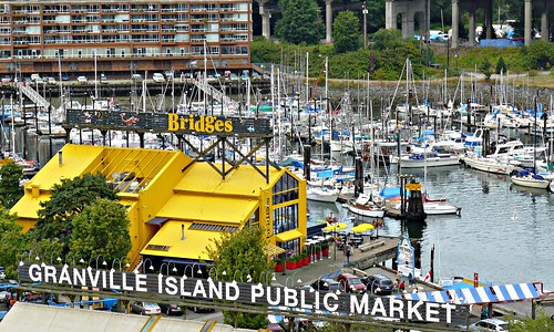
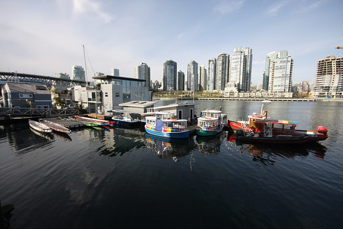
Granville Island is a small island and shopping district in Vancouver, British Columbia, Canada. It is located in False Creek directly across from Downtown Vancouver's peninsula, under the south end of the Granville Street Bridge. The island is now more or less connected with the mainland so it is not technically an island.

Granville Island was once an industrial manufacturing area, but is now a major tourist destination, providing amenities such as a public market, a large marina, a hotel, the Emily Carr University of Art and Design (named in honour of the artist), various theatres including the Arts Club Theatre Company and Carousel Theatre, and various shopping areas clustered around the one industrial outpost remaining, a cement plant. The island is very popular with tourists and locals alike.

Granville Island Public Market, Vancouver, BC, Canada by ynysforgan_jack.

Passenger ferry service from Granville Island to Downtown Vancouver is provided by two ferry companies, False Creek Ferries and Aquabus.

Since its redevelopment in the 1970s, Granville Island has maintained a healthy community of craft studios, including a glassblowing studio, a printmaking shop, a luthier, a master shoemaker, various jewellers, and the B.C. Potter's Guild. A weekly farmer's market has also been ongoing since the island's redevelopment.

Granville Island Brewing Co. is also the name of a beer company which originated on Granville Island in 1984, but whose main base of operations was moved to Kelowna, British Columbia some time later. It does continue, however, to brew some of its varieties at the original site, and offers beer-tasting tours.

In 2004, Project for Public Spaces named Granville Island "One of the World's Great Places". [1]

Granville Island Canada Day Festivities by digitAL animAL.

History

The city of Vancouver was once called Granville until it was renamed in 1886, but the former name was kept and given to Granville Street, which spanned the small inlet known as False Creek. False Creek in the late 19th century was more than twice the size it is today, and its tidal flats included two sandbars over which spanned the original, rickety, wooden Granville Street bridge. Those two sandbars would eventually become Granville Island.

In 1915, with the port of Vancouver growing, the newly formed Vancouver Harbour Commission approved a reclamation project in False Creek for an industrial area. A 35 acres (14.2 ha) island, connected to the mainland by a combined road and rail bridge at its south end, was to be built. Almost 1 million cubic yards (760,000 m³) of fill was dredged from the surrounding waters of False Creek to create the island under the Granville Street Bridge. The total cost for the reclamation was $342,000. It was originally called Industrial Island, but Granville Island was the name that stuck, named after the bridge that ran directly overhead.

North-west Granville Island in 1922. Many of the buildings shown here are still standing as of 2006.

The very first tenant, B.C. Equipment Ltd., set the standard by building a wood-framed machine shop, clad on all sides in corrugated tin, at the Island's west end. (Today the same structure houses part of the Granville Island Public Market.) By 1923 virtually every lot on the Island was occupied, mostly by similar corrugated-tin factories. The first tenants of Granville Island tended toward newer, secondary industries serving the forest, mining, construction, and shipping sectors. Factories made roof shingles, chain, barrels, wire rope, nails, saws, paint, cement, rivets, boilers, and many types of industrial machinery. In 1930, 1,200 workers were employed on the island mostly arriving at work by streetcar. There was a special stop in the middle of the Granville Street Bridge where they descended several flights of stairs to the Island below. The only other access to the Island was a pair of road and rail bridges leading to the Creek's south shore.

During the Great Depression, one of Vancouver's several hobo jungles sprang up on the False Creek flats opposite Granville Island's north shore.[2] "Shackers" lived on the island, in town, or in floathouses, and survived by fishing and beachcombing and sold salmon, smelt, and wood door to door or at the public market on Main Street.[3] They were basically self-sufficient and were left alone.

The Depression saw several sawmills around False Creek shut down, yet secondary industries on Granville Island survived. They successfully lobbied the overseers to lower their rents, and withheld civic taxes on the grounds that the city had no jurisdiction over federal property. The ensuing court case went all the way the House of Lords in London (then the highest court of appeal). The tenants lost, but Europe, being at war, depended on the industrial factories on Granville Island. The island was considered so vital to the war effort that in 1942, after the Japanese attack on Pearl Harbor, special identification cards were issued to workers to prevent saboteurs from infiltrating it.

Granville Island and Granville Street Bridge as seen from western False Creek

In 1949 city officials gave eviction notices to seven hundred people when a typhoid scare and a grisly murder prompted the city to remove the shantytown.

In the postwar period, demand for heavy industrial output declined. The sawmills and even the Island's factories were becoming oily, dirty firetraps. Factories routinely discharged waste and other pollutants directly into the surrounding water. To keep its tenants, the overseers charged some of the lowest industrial rents going, which meant the declining businesses hung on, and no newer, tertiary industries took their place.

As business declined, officials began entertaining a new reclamation plan. The idea was to fill in the remainder of the Creek to create more industrial land, remove the water access (on which many of the existing factories still depended), and turn Granville Island into a land-locked plot. The Creek was saved by the hefty $50-million price tag estimated to fulfill the reclamation plan. Just 6 acres (24,000 m2) were reclaimed from the Creek along the Island's south channel. It was technically no longer an island but instead a peninsula.

In 1950, plans also started for the construction of a soaring, new, eight-lane Granville Street Bridge to replace the 1909 swing span that still stopped traffic every time a larger vessel passed underneath.

The island was in serious decline as fire struck factory after factory. Rather than rebuild, owners either relocated or left industry alltogeter. Trucks replaced barges and trains as the main means of transportation, and the Island's cramped, inner-city location no longer looked attractive to industry. Slowly, the vacant lots began to outnumber the occupied ones.

In the 1970s, the site was redeveloped by the federal government, spearheaded by Canadian government minister Ron Basford. It transformed the site into a 'people-friendly' place with various uses, from parkland to housing to public exhibition space. Today, the site is still owned and managed by the government through the Canada Mortgage and Housing Corporation agency. The redevelopment originally cost the government $19 million and the site now generates an estimated $35 million per year in taxes.

Buskers

Granville Island plays host to a variety of buskers throughout the year. Busking is encouraged by the Granville Island administration, and a group has been created to oversee the activity. Performers must purchase a license prior to busking, and are restricted to specific areas of the island. As of 2007, approximately 100 performers are registered to busk, including musicians, jugglers, magicians and other street performers. Buskers can be found most of the day at two main outdoor locations. One being the triangle square in front of the La Baguette Bakery, and the other being the Market Courtyard behind the public market on the waterfront. Unamplified buskers can also be found at various indoor and outdoor locations throughout the island. Performances take place year-round with the majority taking place during the busy tourist season (May-September).
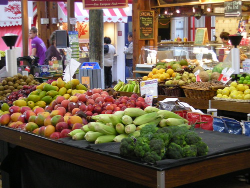
Public market

Over one hundred permanent and temporary vendors sell a variety of food and crafts in the market buildings. Hours of operation are 9:00am to 7:00pm, seven days per week, except Christmas and New Years.

Followers