

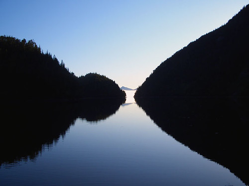
They lie on the edge of the province's collective memory like a dream scarce remembered; mythical and elusive, full of meaning and great beauty, yet incomprehensible to the waking mind. Impossible not to marvel at, and revel in, these are the Queen Charlotte Islands, arguably one of the most beautiful and diverse landscapes in the world. This group of islands nestled under the Alaska panhandle is the ancestral home of the Haida - the West Coast Aboriginals who have lived here for thousands of years.
According to Haida legend, Haida Gwaii, as it is now known - is the place where time began. There is an older name for this place, a name that comes from the mists of time and seems to be the most appropriate name of all: Xhaaidlagha Gwaayaai - Islands at the Boundary of the World. Certainly it is not hard to miss the spiritual, even mystical nature of the place. The unusual and abundant flora and fauna that thrive in this Galapagos of the North and the marine and wildlife diversity of the surrounding waters and forests make it an ecological marvel.

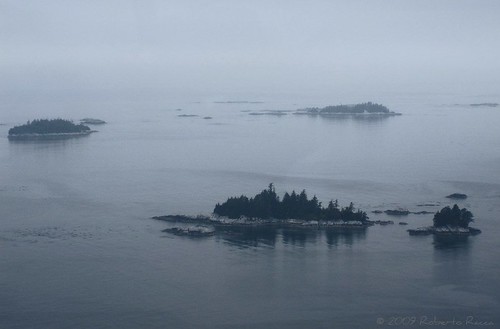
There are 1,884 islands in the archipelago, a mixture of snow-top mountains and fiords that plunge into the sea, mist-enshrouded forests and windswept sandy beaches. The seven largest of the islands are - from north to south - Langara, Graham, Moresby, Louise, Lyell, Burnaby, and Kunghit Island. They rise as peaks of a submerged mountain chain, with the tallest peaks perpetually capped in snow. Just 2 or 3 kilometres offshore, the continental shelf falls away dramatically to the immense depths of the Pacific Ocean. Haida Gwaii is the most active earthquake area in Canada. Natural landslides are a common occurrence, and scarred mountainsides are visible from the fjord-like inlets. The total land area of Haida Gwaii is approximately 3,840 square miles; 156 miles (250 km) from north to south.
Haida Gwaii - islands of the people - has been home to the Haida people for as long as oral history and archaeology have recorded occupation of the islands - at least 7,000 years. At least 14,000 people have lived in over 126 known village sites. Following first contact with Europeans, the population plummeted to 589 by 1911, all resident in either Skidegate or Old Masset. Today, the Queen Charlottes are less populated, at 6,000 people, than they were a century ago when Haida communities thrived along the shores. Today, two out of three Haida live off-island, many of whom are planning to return.
The islands were the first place in British Columbia discovered and recorded by Spanish explorer Juan Perez in July 1774. Fur traders followed a decade later and were the only visitors for the next 100 years, with a major impact on Haida culture. In the 18th and 19th centuries the area was a thriving fur trading centre, as the Europeans arrived in huge sailing ships to trade in the Haida villages.
The islands were named after HMS Queen Charlotte, Lord Howe's flagship named in honour of Queen Charlotte, wife of King George III. Dispatched by King George's Sound Company to trade in sea otter furs between the Pacific coast of America and China, Captain George Dixon named the islands after his vessel in the summer of 1787.
There is a continuum of rich and lively history here that belies the quiet wilderness of the islands today. The people still make their living in traditional ways - off the land. Each island community has its own unique features that reflect the richness of the culture, geography, and history. A microcosm of the British Columbia coast, these sparsely populated, beautiful islands offer an escape to a rough-edge paradise. There are countless beaches, streams, fishing holes, coves, and ancient First Nation villages to explore. Many unique subspecies of flora and fauna share these islands with the residents. Visitors to these enchanting islands will never forget their visit.
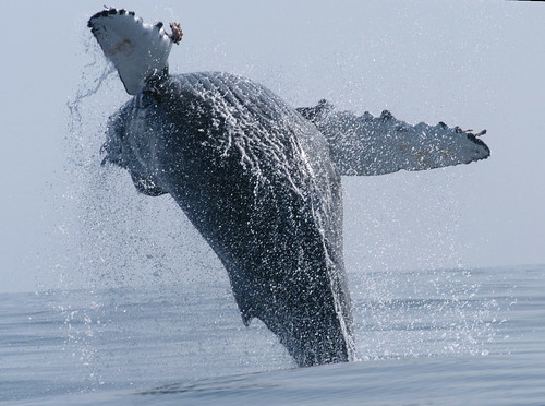
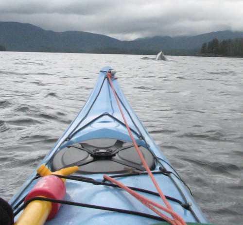
In spite of modern transportation and communication, the islands are still relatively isolated, an attraction in itself, and recreation and native culture are the main attractions. Sport fishing, hiking, camping, kayaking, boating, whale watching, beachcombing and sightseeing are the major recreational activities.
The Queen Charlotte Islands is largely a resource-based economy. The main industries are logging, commercial fishing, mining, and tourism. The local economy is heavily dependent upon the forest industry, located primarily on the east and west sides of Graham Island, with a smaller portion on northwest Moresby Island. The timber supply area is around half a million hectares of western hemlock (49%), western red cedar (30%), Sitka spruce (21%), and yellow cedar (less than 1%). Salmon, herring, halibut, black cod, and crabs are the main products in commercial fisheries. In addition to these industries, employment is also high in the service industries and government, which employs 32% of island residents.
Population: 6,000
Location: The Queen Charlottes are located in British Columbia, Canada, west of the northern BC town of Prince Rupert. Two Islands, Graham Island to the north and Moresby Island to the south, comprise the majority of the land mass. For transport information see Getting to the Queen Charlotte Islands on page two - follow the link below to 'More Attractions'.
View a map of the Queen Charlotte Islands.
-
Graham Island
A waterfall cascades from a lake on Mount Moresby, Queen Charlotte Islands, BC
Graham Island is the largest of the Queen Charlotte Islands, covering 2,500 square miles (6,500 sq km), and is the most accessible and populated of the islands, with most of the significant communities.
- Moresby Island
Moresby Island is the smaller and less accessible of the two main islands, with less than 18 miles (30 km) of public roads.
- Sandspit
The hamlet of Sandspit, on the northeastern tip of Moresby Island, is the Gateway to Gwaii Haanas. The only settlement on Moresby Island, Sandpit is the location of the main airport for the Queen Charlotte Islands. Sandspit's history goes back to at least one ancient Haida Village, Kil, which was situated east of Haans Creek. The first settlers at Sandspit established farms and ranches around the grassy flats.
- Queen Charlotte City
The first registered town site on the Islands, the laid-back fishing village of Queen Charlotte City is located along the shores of Bearskin Bay, 5 kilometres west of the ferry terminal at Skidegate Landing. Known as Queen Charlotte or just Charlotte by the locals, the administrative centre for the Queen Charlotte Islands is a small thriving village of government offices, a hospital and a variety of shops and accommodations.
- Skidegate
The Haida community of Skidegate, on the shores of Rooney Bay, was known for years as Skidegate Mission. Located 2km north of the ferry terminal at Skidegate Landing, Skidegate is the cultural centre of the Haida, where the visitor can examine art and cultural artifacts first hand. The two ferry docks at Skidegate Landing serve ferries to Prince Rupert on the BC mainland and to Alliford Bay on Moresby Island.
- Tlell
Originally a Haida fish camp, and eventually established by ranchers and farmers from England, Tlell is now home to a colourful collection of artisans, earning the reputation of being the heart of the islands' art community. Located 43 kilometres north of the ferry terminal at Skidegate Landing, Tlell is a scattered settlement along the east coast of Graham Island, marking the southeast corner of Naikoon Provincial Park.
- Port Clements
At the estuary of the Yakoun River, on Masset Inlet, the logging and fishing village of Port Clements is a wonderful place to observe the giant trees of the temperate rainforest. Established in 1907, Port Clements became the first incorporated town in the Queen Charlotte Islands in 1914. Port Clements became the supply centre for giant spruce trees used in the construction of First World War military airplanes.
- Juskatla
Located off Masset Sound on Graham Island, south of Port Clements, the logging camp of Juskatla was established on Mamin Bay in Juskatla Inlet in the 1940s, to supply spruce for warplanes.
- Masset
The small village of Masset is the largest town on the Queen Charlotte Islands. Located a few kilometres south of the Haida village of Old Masset, at the northern end of Graham Island, Masset is the northern gateway to Naikoon Park.
- Masset Inlet
The ecologically unique Masset Inlet is a large protected saltwater inlet with a rocky shoreline located to the south of Masset Sound in the centre of Graham Island. Connected to Dixon Entrance by Masset Sound, Masset Inlet features many rivers, estuaries and bays, including Juskatla Inlet and Delkatla and Kumdis Sloughs.
- Old Masset
The Haida village of Old Masset, also known as Haida, is located on the east shore of Masset Inlet, on the site of three ancient Haida town sites. Old Masset is the administrative seat of the Council of the Haida Nation, and is home to about 600 Haida, including some well-known native carvers.
- North Beach
The fabulous North Beach in Naikoon Provincial Park is accessed from Masset, along scenic Tow Hill Road that cuts through a rain forest. At North Beach, according to Haida legend, raven first brought people into the world by coaxing them out of a clam shell, making North Beach the site of creation.
- Naden Harbour
At the head of Virago Sound on the north coast of the Queen Charlotte Islands, is pristine Naden Harbour, the remote location favoured by fishing lodges that attract sports anglers to the world-class salmon fishing offered by the islands.
- Langara Island
The remote and rugged Langara Island at the northwestern tip of the archipelago has a couple of small native villages, ancient rain forest, an impressive colony of seabirds, and a beautifully restored 1913 lighthouse. Langara has luxurious fishing lodges, and sportfishing companies abound, offering fabulous salmon and halibut fishing.
- Port Louis
Amidst unparalleled scenic beauty, and some of the most rugged shoreline on the west coast of the Queen Charlotte Islands, Port Louis serves as a comfortable home base for adventurers seeking world-class sports fishing.
- Rennell Sound
Rennell Sound is the largest sound on the west coast of the Queen Charlotte Islands, cutting 18 miles (29 km) into Graham Island, the larger of the two main islands that comprise Haida Gwaii. Bounded by the snowcapped Queen Charlotte Mountains, the deep inlet offers wonderful recreational and sightseeing opportunities. The rugged coastline, beautiful crescent beaches and excellent beachcombing along the gravel shoreline, great hiking, camping, fishing and kayaking make the trip very worthwhile.
- Kano Inlet
The beautiful Kano Inlet is located on the west coast of the Queen Charlotte Islands, near the southwest end of Graham Island. There are no communities in this area, which includes the western portion of the Queen Charlotte Mountains.
- Alliford Bay
On the north coast of Moresby Island is Alliford Bay, the southern terminus of the important inter-island ferry between Alliford Bay and Skidegate Landing on Graham Island. Alliford Bay is located a 15-minute drive from the airport at Sandspit.
- Moresby Camp
The ancient logging site at Moresby Camp is the closest road access to Gwaai Haanas National Park. Moresby Camp serves as a floatplane and kayak departure point for those venturing into the park, 30 miles (50 km) to the south.
- Louise Island
Louise Island is enveloped by Moresby Island, Hecate Strait and other islands on the east coast of the Queen Charlotte Islands. The mountainous Louise Island is home to the ancient Haida village of Skedans, and one of the largest displays of totem poles in these mystical islands.
- Kiusta and Lepas Bay
The old villages at Kiusta and Langara Island were the original trading centres for sea otter furs between the Europeans and Haida for this part of the Pacific Northwest Coast. Today, the site of the ancient Kiusta village is part of the Rediscovery Program, a youth program that encourages the young people of the province to get in touch with their cultural heritage. Some of the earliest contact between native Haida and whites occurred at Kiusta and Yaku. The first Rediscovery camp for local youth is located at Lepas Bay on the northeast tip of the Queen Charlotte Islands.
(poverty alleviation) Hello Sir/Madam Have you been refused at the bank because your credit does not meet their standards? Do you dream of owning your own home, but were denied a mortgage due to high interest rates or insufficient credit? Is your business down? Do you need money to boost your business? had explainable late payments, over-indebtedness, divorce or loss of employment or other, You will be able to have a second chance at credit between individuals. have you learned about the great loan campaign offered by Mr Remis Canales de Trans- CIC-Banks? I'm telling you about it because it offers loans of up to $150,000 at a very low rate of 2.59%, and it even left me 4 months before I started not being reimbursed. contact Mr. Remis Canales if you have a good project that needs financing.
ReplyDeletedgcanales22@gmail.com
+14503005817